DIGITAL SOLUTIONS
Geosolutions
Global leaders in geotechnical, geospatial and structural monitoring, protecting people, assets and enabling operational uptime.
DIGITAL SOLUTIONS
Geosolutions
Global leaders in geotechnical, geospatial and structural monitoring. Protecting people and assets, and enabling operational uptime.

DIGITAL SOLUTIONS
Geosolutions
Global leaders in geotechnical, geospatial and structural monitoring. Protecting people and assets, and enabling operational uptime.
Global leaders in geotechnical, geospatial and structural monitoring. Protecting people and assets, and enabling operational uptime.
Global leaders in geotechnical, geospatial and structural monitoring. Protecting people and assets, and enabling operational uptime.
Geosolutions is a global leader in geotechnical, geospatial and structural monitoring, delivering advanced technologies and actionable insights to help customers manage risk and optimise productivity. We provide our customers with everything, from sensors to services. Our complete, end-to-end portfolio of solutions supports the entire mining, civil infrastructure and energy industries.
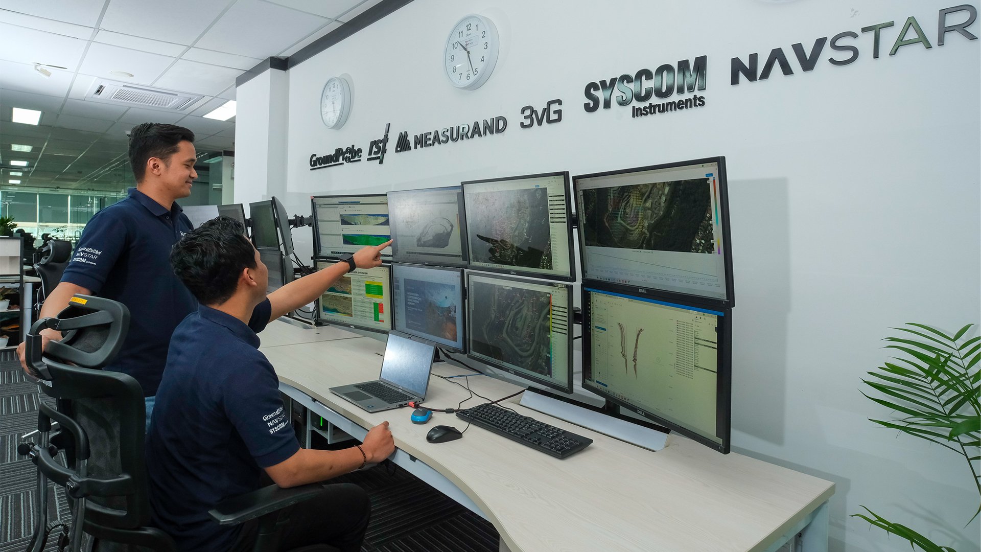
Our ecosystem brings together six of the world’s most trusted monitoring brands—GroundProbe, RST Instruments, Measurand, 3vGeomatics, Syscom Instruments and NavStar, creating the most comprehensive portfolio in the industry.
Part of Orica Digital Solutions, Geosolutions is backed by a team whose expertise and global reach are grounded in Orica’s 150 years of experience.
Why choose Geosolutions?
By combining long-standing technical expertise with tools designed for the realities of mining, infrastructure and energy operations, customers gain more than instruments. They have access to people who understand how ground and structures behave and who can help turn data into informed decisions
Backed by Orica’s global network and long history in high-risk environments, we focus on giving teams the clarity they need to work safely and make safety-critical decisions with confidence.
The full range
The full range
Loading results
Global leader in geotechnical, geospatial and structural monitoring
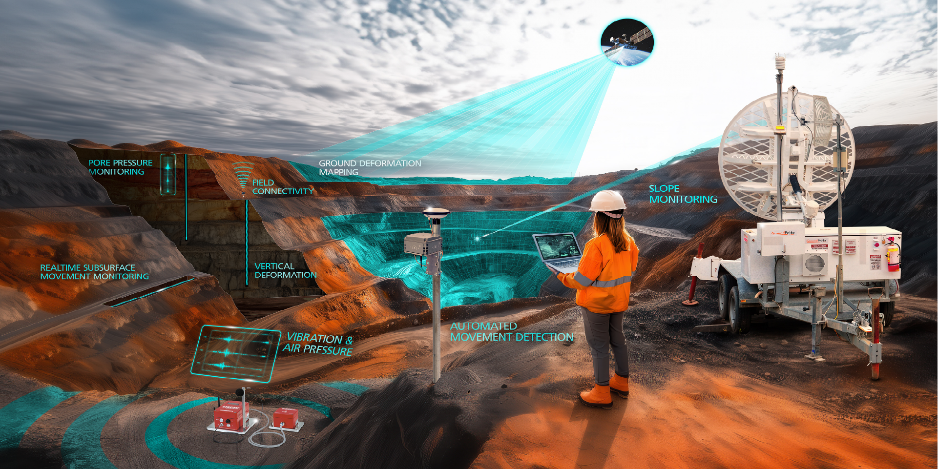
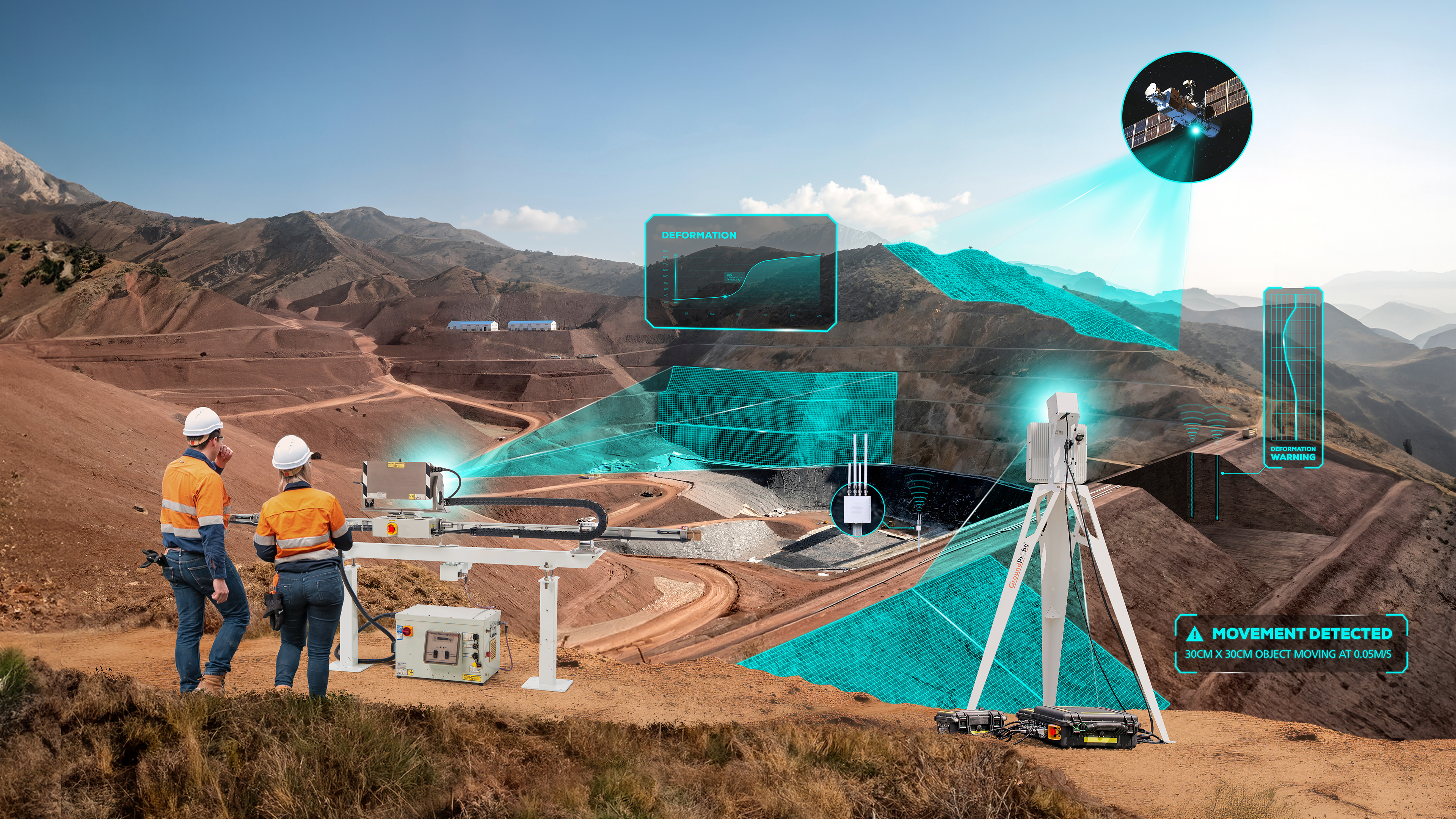
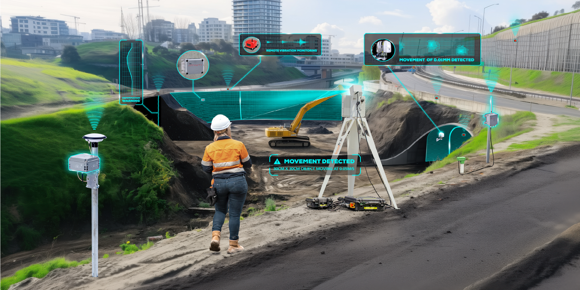
Geosolutions offers real-time and periodic, safety-critical and background, surface and sub-surface data analysis. Our technologies enable customers to monitor ground stability, structural integrity, and environmental conditions, delivering critical data and geotechnical insights to support risk-informed decision-making.
The Geosolutions portfolio combines known technologies and sensors, including radars, inclinometers, ShapeArrays, piezometers, GNSS, InSAR, vibration sensors and more.
Discover how our technologies deliver measurable value for your operation:
Risk managment
Through our predictive technologies and software solutions, our customers can monitor and detect geotechnical movement, understand when it becomes a problem, and determine when a collapse is likely to occur.
Our reactive technologies detect, track, and alert on moving geohazards in real time, giving our customers and communities advance warning of a breach or collapse.
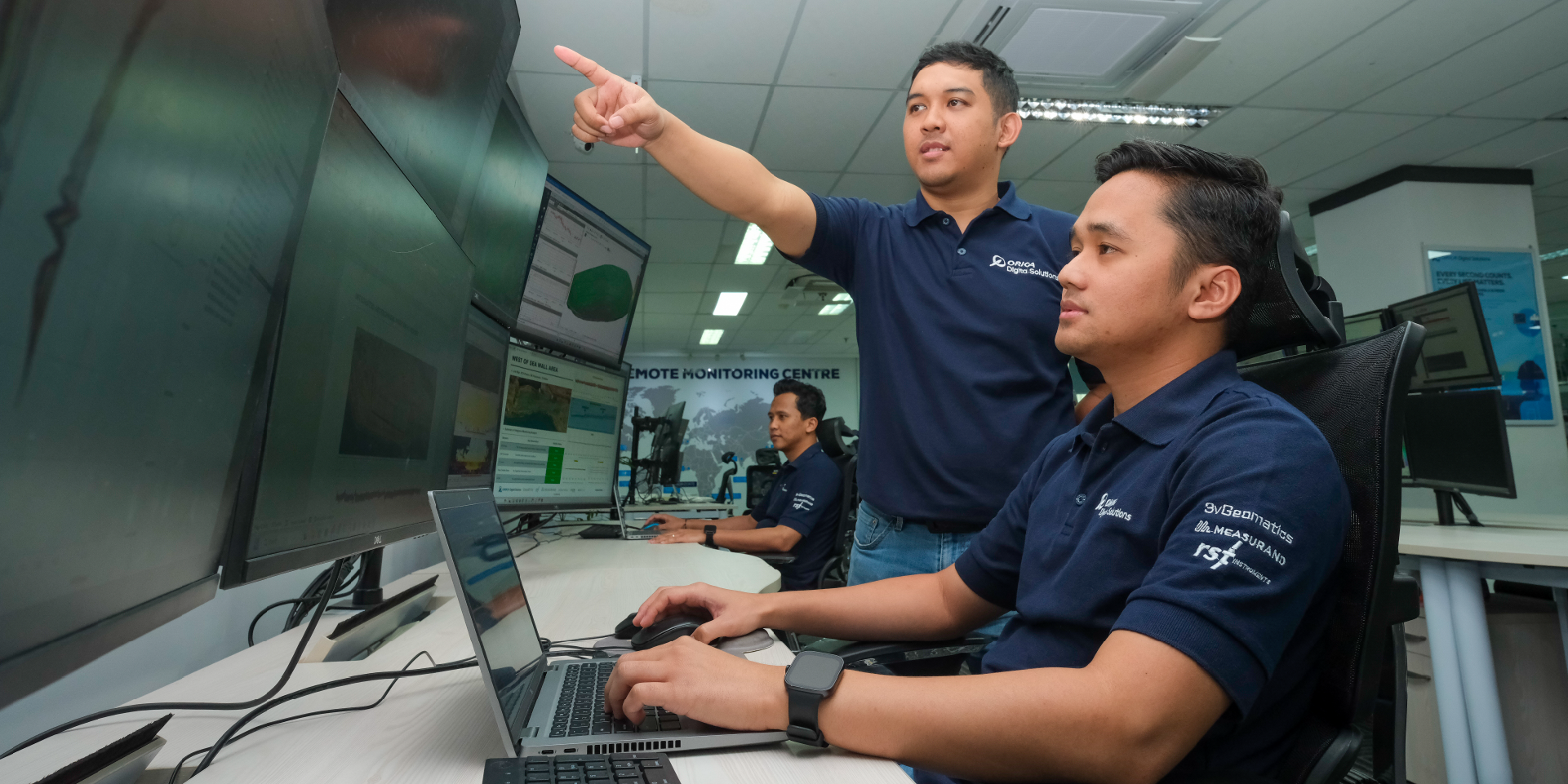
Comprehensive monitoring platform
Our monitoring solutions measure large-scale areas from high‑production mine sites to entire rail, road, and pipeline networks using integrated geospatial, ground-based, and structural instrumentation.
We also monitor movement in airports, bridges, water dams, tailings dams, mines, and tunnels.
Geotechnical Specialist Services
Your trusted partner in managing geotechnical risk and slope stability for mining and civil operations.
Backed by the world’s largest geotechnical team, over 170 engineers and radar operators. GSS delivers faster decisions and safer outcomes, built on a decade of unmatched real‑world experience
Global 24/7 dedicated support
With 180+ years of combined experience and a global Geosolutions team of over 800 experts.
We have the scale and local presence to deliver trusted advice, support, and services wherever our customers operate.
Data security and reliability
Our systems protect data from capture through transmission to long‑term storage, ensuring accuracy and security at every stage. Operators can trust the information they use for daily monitoring, regulatory reporting, and internal decisions.
Our valued customers
Our technologies enable operations to confidently make strategic decisions which deliver efficiencies and enhance productivity.


News and Media
Our Industry Solutions
Our Industry Solutions
Driven by innovation and backed by our global R&D and technical networks, we deliver solutions that solve real operational challenges.
Explore more
Orica Digital Solutions’ Geosolutions, a global leader in geotechnical, geospatial and structural monitoring. We deliver a complete portfolio, from sensors to services, for mining and civil infrastructure customers. Our expertise is grounded in Orica's innovation and technical excellence that span more than 150 years.
Contact an expert
Contact an expert
Whether you need support or simply want to learn more, reach out to our Geosolutions team. We’re here to help.